In the Girraween National Park.

|
<11,300 Ha
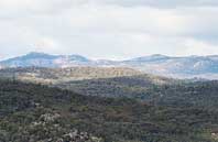
Girraween is a park of steep sided granite hills, large angular tors and boulders, precariously
balanced rocks and expansive outcrops set among the Granite Belt's orchards, farms and vineyards.
It is dissected by gullies and valleys where creeks flow over granite beds and open eucalypt forest
is established on the rock strewn slopes, ridges and flats.
Girraween 'Place of Flowers' is situated on the northern extremity of the New England uplands at an
average elevation of 900 metres. Its granite habitat is unique in Queensland with the floral and faunal
communities resembling more southern types.
Some plants and animals have their sole Queensland distribution in Girraween.
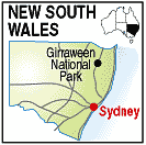
The park extends to the Queensland - New South Wales Border and has a common border with the Bald Rock
National Park.
|